2026.06.17(Мі) 10:50
 БГРАХИРгСю СіИщНХЙЎ


|

НУДТ СіГ 11РЯКЮХЭ 12РЯБюСі ПяИЊБК ЖѓЦфЗчСю ИЎСЖЦЎПЁМ АГУжЕШ '2026Гт АцЛѓКЯЕЕ СіРћОїЙЋ ПіХЉМѓ ПЌБИАњСІ ЙпЧЅДыШИ'ПЁМ ПЕУЕНУ СіРћСЄКИАњ ШЋАРЧ СжЙЋАќРЬ ПьМіЛѓРЛ МіЛѓЧпДйАэ СіГ 16РЯ ЙпЧЅЧпДй. АцКЯЕЕ ХфСіСЄКИАњ СжАќРИЗЮ ПИА РЬЙј ПіХЉМѓРК ЕЕГЛ 22АГ НУЁЄБК СіРћ ЧрСЄ ДуДч АјЙЋПјЕщРЬ И№ПЉ ХфСі ЧрСЄ МКёНК ЙпРќ ЙцОШРЛ И№ЛіЧЯДТ РкИЎЗЮ ИЖЗУЕЦДй. ПЕУЕНУДТ 1Тї МИщ НЩЛчИІ ХыАњЧб УжСО 3АГ НУЁЄБКПЁ ЦїЧдЕХ КЛМБ ЙпЧЅИІ СјЧрЧпДй. ШЋ СжЙЋАќРК 'AI БтЙн ЧрСЄБИПЊ АцАш КвКЮЧеСі ЙЎСІ ЧиАс ЙцОШ'РЛ СжСІЗЮ, НЧСІ ЧіРх ЕЕИщАњ ДыРхРЬ РЯФЁЧЯСі ОЪДТ АцАш СіПЊРЧ КвКЮЧе ЙЎСІИІ ГЏФЋЗгАд КаМЎЧпДй. ЦЏШї ЕхЗа КёЧр УМАшПЭ ЖѓРЬДй(LiDAR), AI ПЕЛѓКаМЎ БтМњРЛ РЖЧеЧи СіРћКвКЮЧеСіИІ РкЕПРИЗЮ ХНСіЧЯАэ СЄКёЧЯДТ БИУМРћРЮ ЧСЗЮММНКИІ СІНУЧи СіРћ ЧрСЄРЧ Е№СіХа РќШЏРЛ ОеДчАхДйДТ ШЃЦђРЛ ЙоОвДй. РЬЗЮНс ПЕУЕНУДТ СіГЧи РхЗСЛѓПЁ РЬОю ПУЧи ПьМіЛѓБюСі АХИгСуИч СіРћ ПЌБИ КаОпПЁМ 2Гт ПЌМг МіЛѓРЧ ПЕПЙИІ ОШОвДй.
СіРкУМАЁ ЧрСЄБИПЊ АцАшИщПЁМ ЙпЛ§ЧЯДТ СжЙЮ АЃРЧ ХфСі АцАш АЅЕюРЛ ДмМјШї РќХыРћРЮ СіРћ УјЗЎ ЙцНФПЁ РЧСИЧЯСі ОЪАэ, AI ПЕЛѓ КаМЎАњ ЖѓРЬДй Ею 4Тї ЛъОїЧѕИэ ЧйНЩ БтМњРЛ МБСІРћРИЗЮ АсЧеЧи РкЕП ХНСі И№ЕЈРЛ БИУрЧб НУЕЕДТ АэЕЕШЕШ АјАЃСЄКИ ЧрСЄ ЛчЗЪЗЮ ЧЎРЬЕШДй. ЦЏШї РЮСЂ СіРкУМ АЃРЧ АјЕПАќИЎ УМАш БИУрАњ СіРћРчСЖЛчЛчОї ПьМБ УпСјРЬЖѓДТ НЧЙЋРћ ДыОШРЛ СЄЙЋРћРИЗЮ СІОШЧи АцКЯ ЕЕГЛ СіРћ ЧрСЄРЧ ЧЅСи АЁРЬЕхЖѓРЮРЛ СІНУЧб ДыИёРК ПЕУЕНУРЧ ПьМіЧб ЧрСЄ БтШЙЗТРЬ ЙнПЕЕШ АсАњДй.
БзЗЏГЊ РЯАЂПЁМДТ РЬЗЏЧб УЗДм БтМњ БтЙнРЧ ПЌБИ МКАњАЁ ДыПмРћРЮ МіЛѓ НЧРћРЬГЊ РЯШИМК ЙпЧЅ УрСІПЁ ИгЙЋИЃСі ОЪБт РЇЧиМДТ, НЧСІ ХИ СіРкУМПЭРЧ АцАш КаРя ЙпЛ§ НУ ЛчШФРћРИЗЮ Й§Рћ ШПЗТРЛ ЙпШжЧв Мі РжДТ 'ЧрСЄРћЁЄНЧЙЋРћ СІЕЕШ Зъ(ЦїНКЦЎ АЁРЬЕхЖѓРЮ)'РЬ УЖРњЧЯАд МіЙнЕЧОюОп ЧбДйДТ СіРћРЬ ГЊПТДй. ОЦЙЋИЎ AIПЭ ЕхЗаРИЗЮ СЄШЎЧб АцАшИІ ЕЕУтЧЯДѕЖѓЕЕ, СЄРл РЮСЂ СіРкУМ АЃРЧ РЬЧиАќАшАЁ ЛчШФРћРИЗЮ УцЕЙЧв АцПь РЬИІ АСІЧв Й§Рћ БИМгЗТРЬ ОјДйИщ АсБЙ ПЙЛъИИ ГЖКёЧб БтМњ РќНУ ЧрСЄРИЗЮ РќЖєЧв РЇЧшРЬ ХЉБт ЖЇЙЎРЬДй. РЬПЁ ЕћЖѓ ПЕУЕНУДТ РЬЙј ПіХЉМѓ СОЗс РЬШФ АцКЯЕЕ Йз РЮСЂ СіРкУМПЭ ПЌАшЧи 'ЛчШФ СіРћ АцАш АјЕП НЩРЧРЇПјШИ'ИІ ЛѓМГШЧиОп ЧЯИч, ЕЕУтЕШ AI КаМЎ ЕЅРЬХЭИІ НЧСІ СіРћАјКЮПЁ НЧНУАЃРИЗЮ ШЏЗљЧЯДТ ШФМг НЧЙЋ КИПЯУЅРЛ ДмЧрЧиОп ЧбДй. РЬЗЏЧб РЏБтРћРЮ ЛчШФ МјШЏ ЧрСЄРЬ ЕоЙоФЇЕЩ ЖЇ КёЗЮМв УЗДм БтМњ ЕЕРдРЛ РЇЧб ПЙЛъ ХѕРдРЬ ДмЙпМК ПЌБИ ЙпЧЅИІ ГбОю НУЙЮЕщРЧ РчЛъБЧРЛ ЧзБИРћРИЗЮ КИШЃЧЯДТ НЧСњРћРЮ БЙРЭРИЗЮ ФЁШЏЕЩ Мі РжРЛ АЭРЬДй.
[ПЕЙЎЙјПЊ БтЛч-AIШАПы]
Gu Gyeong-seung, Chief of the Cadastral Information Division of Yeongcheon City, stated, "This research is a meaningful achievement that confirmed the possibility of practically resolving boundary issues between regions by utilizing AI-based technology. We will continue to make efforts to provide more accurate land administration services to citizens by increasing the reliability and efficiency of cadastral administration." Yeongcheon City has achieved external results by presenting a digital cadastral administration model that combines artificial intelligence (AI) and advanced drone technology to resolve long-standing land disputes occurring at the administrative boundaries between adjacent local governments.
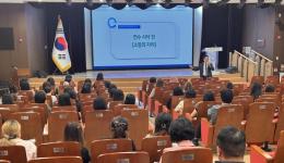
The city announced on the 16th that Han Hong-gang, a competent official of the Cadastral Information Division of Yeongcheon City, won the Excellence Award at the '2026 Gyeongsangbuk-do Cadastral Business Workshop Research Project Presentation Competition' held at Laperouse Resort in Ulleung-gun from the 11th to the 12th. The workshop, hosted by the Land Information Division of Gyeongsangbuk-do, was organized as a place for cadastral administration officials from 22 cities and counties in the province to gather and seek ways to develop land administration services. Yeongcheon City was included in the final three cities and counties that passed the first document screening and proceeded with the main presentation. Official Hong sharply analyzed the non-coincidence problem in boundary areas where real field blueprints and registers do not match, under the theme of 'AI-based Administrative District Boundary Non-coincidence Resolution Measures.' In particular, he received high praise for accelerating the digital transformation of cadastral administration by presenting a specific process for automatically detecting and rearranging cadastral non-coincidence areas by fusing drone flight systems, LiDAR, and AI image analysis technologies. As a result, Yeongcheon City won the Excellence Award this year following the Encouragement Award last year, honoring the glory of winning awards for two consecutive years in the field of cadastral research.
The move where the local government did not simply rely on traditional cadastral surveying methods to resolve land boundary conflicts among residents occurring at the boundaries of administrative districts, but instead preemptively combined core technologies of the 4th Industrial Revolution such as AI image analysis and LiDAR to build an automatic detection model, is interpreted as an advanced spatial information administration case. In particular, politically proposing the establishment of a joint management system between adjacent local governments and the preferential promotion of cadastral resurvey projects highlights Yeongcheon City's excellent administrative planning power, which presented standard guidelines for cadastral administration in Gyeongsangbuk-do.
ЧйНЩ КёЦЧРК, critics point out that for these technology-based research achievements to avoid staying at external award performance or short-term presentation festivals, 'administrative and practical institutionalized rules (post-guidelines)' capable of exerting legal force in a post-manner during real boundary disputes with other local governments must be thoroughly accompanied. This is because no matter how accurate boundaries are derived with AI and drones, if there is no legal binding force to compel them when the interests of adjacent local governments conflict in a post-manner, there is a high risk of degenerating into technical exhibition administrations that waste budgets. Accordingly, Yeongcheon City must permanentize a 'post-cadastral boundary joint deliberation committee' in connection with Gyeongsangbuk-do and adjacent local governments after this workshop ends, and implement follow-up practical supplementations that return the derived AI analysis data to the actual cadastral books in real-time. Only when this organic post-distribution feedback mechanism is supported will budget investments for introducing advanced technologies be translated into substantial national interests of permanently protecting citizens' property rights rather than stopping at short-term research presentations.
 |
РЬМіЧі БтРк leegikook@hanmail.net
|